
2017 Western Canadian Orienteering Championships
Competitor Info - New

2017 Western Canadian Orienteering Championships
Home Page

Introduction
On the July 15-16 weekend, the Manitoba Orienteering Association will host the 2017 Western Canadian Orienteering Championships.
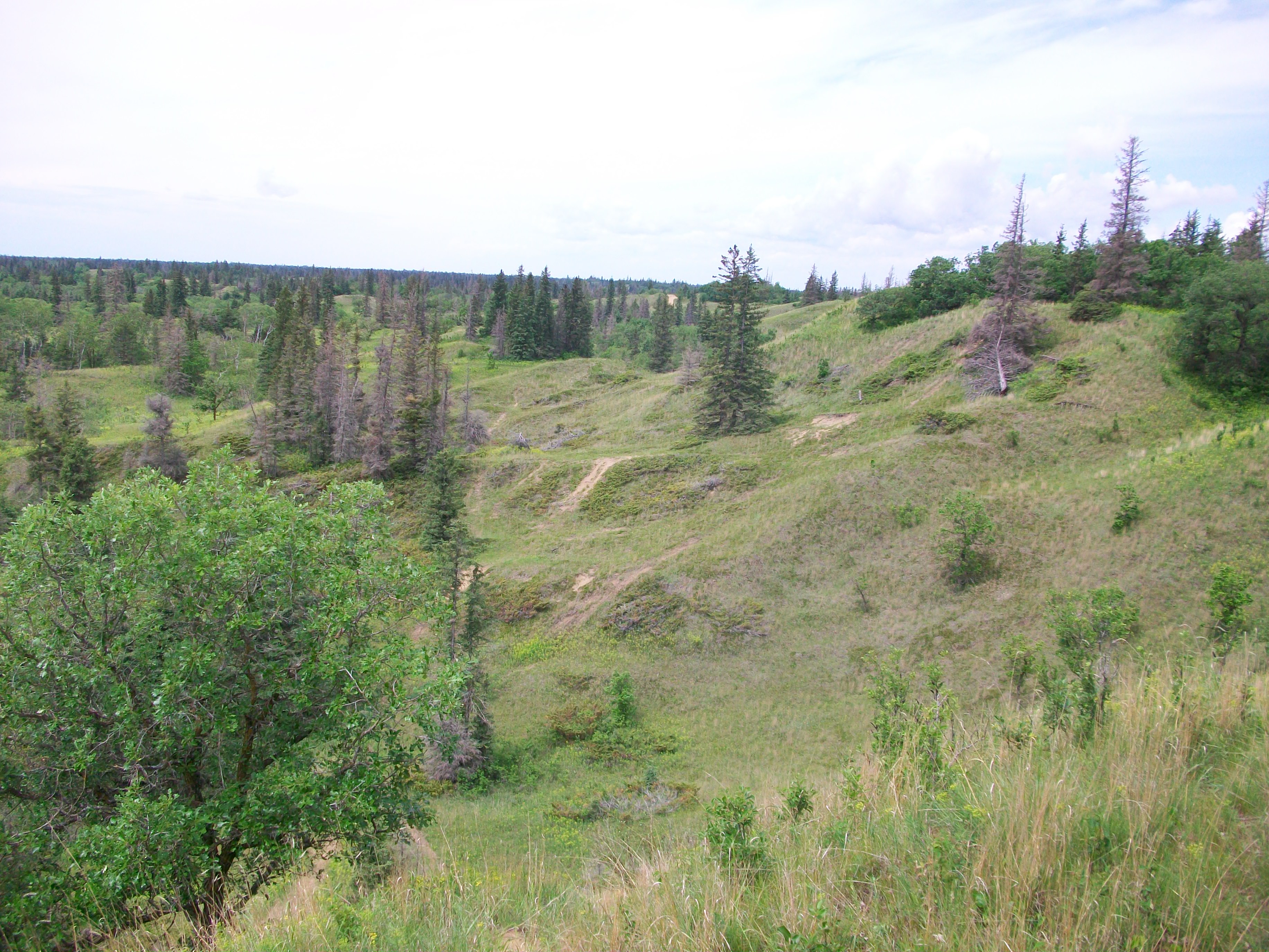
The championships will be held in Spruce Woods Provincial Park on a new map just south of the Hog's Back map (site of the 2009 COCs and 2013 WCOCs).
Yes, the Manitoba prairies may seem like they are a long way from anywhere but don't let that put you off, it is well worth the trip. Apart from some of the most challenging orienteering you will ever experience (see mapper's notes), Spruce Woods Provincial Park is a place well worth visiting for its own sake. It is less than two hours drive west of Winnipeg.
You can expect warm weather in July so after you run head to Kiche Manitou, a popular camping and swimming spot beside the Assiniboine River. Or check out the unique drifting sand dunes of Spirit Sands and the Devils Punch Bowl.
Event Schedule
| Date | Time | Event | Location |
| July 13-14 (Thu/Fri) |
10AM-2PM | Training (See below) |
Spruce Woods (Yellow Quill) |
| July 14 (Fri) | 2PM-8PM | WCOC Model | Spruce Woods (Cypress River Sandhills) |
| July 15 (Sat) | 8AM-10AM | WCOC Model | Spruce Woods (Cypress River Sandhills) |
| 10AM-1PM | WCOC Sprint | Spruce Woods (Cypress River Sandhills) | |
| 2PM-6PM | WCOC Middle | Spruce Woods (Cypress River Sandhills) | |
| 5:45 PM (doors open) 6:30 PM (food served) |
WCOC Banquet | Cypress River Memorial Hall | |
| July 16 (Sun) | |||
| 10AM-3PM | WCOC Long | Spruce Woods (Cypress River Sandhills) |
For orienteering events, the time window is from the first start time to the course closing time.
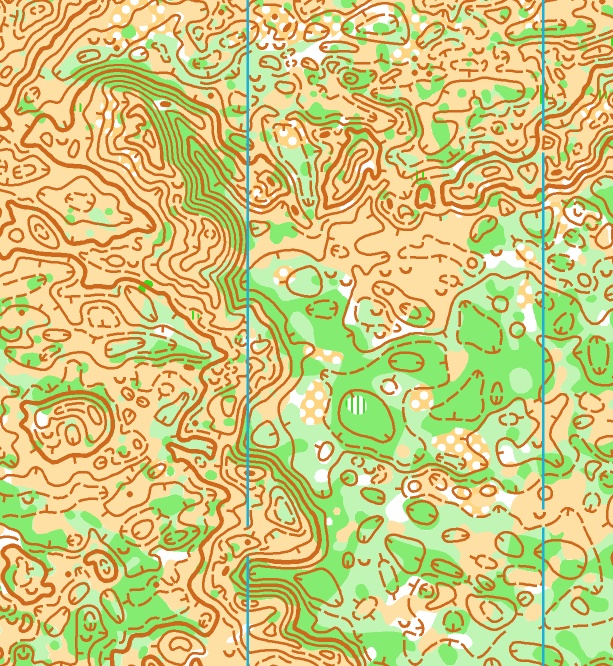
Map
The new map has been named Cypress River Sandhills.
| Sprint | All courses 1 : 5,000 | 2.5m contours | ('Forest' sprint) |
| Middle | Courses 1-8 : 7,500 Courses 9-10 : 10,000 |
2.5m contours | |
| Long | Courses 1-6 at 1 : 7,500 Courses 7-10 at 1 : 10,000 |
2.5m contours |
LiDAR base map produced by Bryan Chubb: "The best base map I have ever worked with" - Rob Plowright (mapper)
Mapper's Notes
Back in the 80's when I was doing the tour of Europe all aspiring elite orienteers do, someone gave me a map of sand dunes in Manitoba. It blew my mind. Not only did the terrain seem uniquely challenging, I was intrigued by the idea of sand dunes so far from the sea (being Australian I had no idea that melting glaciers dump huge quantities of sand). So last year when I was offered the opportunity to do some mapping in those very sand hills I jumped at the chance. Often when you have waited 30 years for something the reality proves to be a bit of a let down. Not in this case. The terrain more than lived up to my expectations. The sand hills of Spruce Woods Provincial Park are an area that should be on every orienteers' bucket list. It was a joy to map - and if you come I think you will find it a joy to orienteer in.
The area covered by this map is true wilderness. Apart from the road and trails that form the map border there are almost no man-made features - just contours and vegetation. The map is predominantly yellow or green. The yellow is mixed grass prairie - very fast running. The wooded areas are a mix of spruce, aspen and oak - usually light to medium green. Always passable but best avoided where possible. This combination of open and wooded areas creates its own navigational challenges. You won't be able to just run straight on a compass bearing. You will need to find ways to weave around the thicker vegetation. The topography ranges from quite flat to very steep sand hills up to 30m high. There are large areas of the very intense contour detail typical of sand dunes, where close map contact and super accurate navigation will be essential. There are also tracts of flatter terrain with vague contour detail. These are often heavily wooded with narrow passages of good running. These labyrinth-like areas will require a very different style of navigation.
Mapper/Course Setter
Rob Plowright was on the Australian National Team from 1983 to 1994. He has been a Professional Mapper since 1989 with experience in Sweden, Italy, Australia, Japan, China, and now Canada, including numerous national championships maps in Australia and Japan and the 1994 World Cup maps in Australia. He also has over 25 years course setting experience including the 1994 World Cup in Australia (Middle & Relay), the 2005 WOC Sprint in Japan, the 2005 Japan Championships (Long), and the 2015 Australian Championships (Long).
Training
We are holding an informal training event on the Thursday and Friday before the championships. This will take place on the Yellow Quill map of Spruce Woods Provincial Park.
This event has a WhyJustRun page at https://moa.whyjustrun.ca/events/view/3002, where you can read more information and register.
Meet Sites
The following Google Map shows the parking locations at Cypress River Sandhills, Cypress River Memorial Hall (for the banquet), and Yellow Quill (for the training event).
View WCOC 2017 in a larger map
Meet Officials
| Meet Director | Patrick Connors |
| Controller | Sheldon Friesen |
| Course Designer | Rob Plowright |
| Course Planners / Setters | Muriel Gamey, Jennifer Hamilton, Larry Konotopetz, Jim Lee, Vern Nelson |
| Onsite Registration | Reine-Marie Guillermic |
| Web Site and Online Registration | Thomas Graupner |
| Start Line | Dave Graupner & Ursula Goeres |
| Finish Line | Tony Connors |
| Timing and Results | Thomas Graupner |
| Event Site Setup and Refreshments | Angela & Rudi Bajt |
| Overnight Security | Garry & Cheryl Atchison |
Contact
Please e-mail any comments or questions about the 2017 WCOCs to info@orienteering.mb.ca.
Updates
November 5: Web site created.
November 8: Corrected dates, removed a selected accommodation.
November 26: Changed the date of the banquet to the Saturday.
Updated the list of meet officials. Replaced the picture and map sample on the
home page.
January 26: Many changes to the home page. Changed the "registration opens"
date to Feb. 10.
February 8: Added fee table to the registration page. Also
registered the domain wcoc2017.ca, which should redirect to this page.
February 10: Registration opened, link added to registration
page.
March 26: Confirmed the banquet location. Added information
about a possible training event on the Thursday and/or Friday.
April 2: Updated the list of meet officials and selected
accommodations.
May 1: Created a WhyJustRun page for the training at Yellow
Quill.
May 20: Added logo and new map sample to home page.
May 26: Updated the table containing map scales.
May 30: Updated the information about park passes on the
registration page. (They aren't required for Friday, Saturday, or Sunday.)
June 13: Added a Google Map to the home page.
June 30: Updated the list of meet officials. Extended the
registration deadline to July 2 due to technical issues.
July 4: Updated information on map scales (on home page) and
added course lengths.
July 5: Updated information on map scales (on home page) again.
July 10 (3PM): Created Competitor Info
page with important information. Slight change to Google Map for Cypress River
Sandhills location. Updated the time for the banquet.
July 10 (7PM): Updated Competitor Info on Map Legend and Meet Site Layout, Meet
Site Locations, Natural Hazards, and Start & Finish Locations.
July 12 (10AM): Added start times.
July 12 (11PM): Updated SI card numbers in start lists.