
Manitoba Sandhills Orienteering Festival

2009 Manitoba Sandhills Orienteering Festival
Western Canadian Orienteering Championships
Important Note
The information on this web page is superseded by the Competitor Handbook.
Please refer to the handbook for the most up-to-date information.
Course Data
The COF Course and Category Guidelines (Amended 2009 – M45-54 on Sprint Course 5 and W21-34E on Sprint Course 4) will be used. See the following table for map scales.
| Event | Map Scale |
| WCOC Sprint | 1 : 5,000 |
| WCOC Middle | 1 : 10,000 |
| WCOC Long | 1 : 10,000 for courses 1-8 1 : 15,000 for courses 9-10 |
Awards
For each competitive class, medals will be awarded to the top three eligible Western Canadian competitors. Prizes will also be given to the top three overall competitors.
To be eligible for WCOC awards you must be a Canadian citizen or a Permanent Resident as defined by the Dept. Citizenship & Immigration and resident in either MB, SK, AB, BC or YK.
Banquet
The WCOC banquet will be held at the Hartney Golf Club on Sunday 23rd August at 5:00PM.
It will be a Barbeque/Buffet style consisting of:
· Rib Eye Steak or Chicken or
Vegetarian Baked Potato
· Selection of salads
· Buns
· Desert
· Tea and coffee
A cash bar will be available.
Officials
| Meet Director | Dave Graupner |
| Course Planners | Tim Lee (Sprint) Jim Lee & Jack Forsyth (Middle & Long) |
| Controllers | Jim Lee (Sprint) Sheldon Friesen (Middle) Tim Lee (Long) |
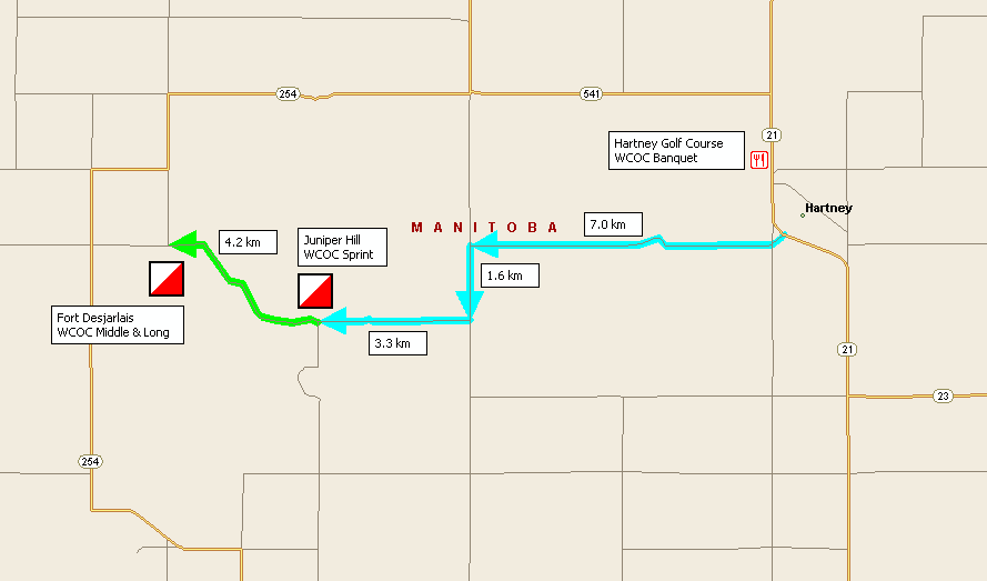
Directions to Parking
WCOC Sprint
Directions to SPRINT: JUNIPER HILL, near Hartney, Manitoba (Fri. Aug. 21 at 4 p.m.)
From Winnipeg take Highway #1 (the Trans Canada) west to Brandon (approximately two hours).
From Brandon take Highway #10 south (18th St.) for about 25 km to Highway #2
Turn right at the junction of Highways #10 and #2 onto, Highway #2.
Take Highway #2 for 44.3 km to Highway #21
Turn left onto Highway #21, heading south, for 12.3 km. Drive past the first turn off on the left for Hartney, take a slight right of half a kilometer and then turn right on Grand Bend Road.
Follow Grand Bend Road for 7 km to a T-Junction.
Turn left at the T-Junction and drive 1.6 km. Turn right and drive 3.3 km. Watch for the orienteering signs.
WCOC Middle and Long
Directions to MIDDLE and LONG: FORT DESJARLAIS, near Hartney, Manitoba (Sat. Aug. 22 at 10 a.m. and Sun. Aug. 23 at 10 a.m. respectively)
From Winnipeg take Highway #1 (the Trans Canada) west to Brandon (approximately two hours).
From Brandon take Highway #10 south (18th St.) for about 25 km to Highway #2
Turn right at the junction of Highways #10 and #2 onto, Highway #2.
Take Highway #2 for 44.3 km to Highway #21
Turn left onto Highway #21, heading south, for 12.3 km. Drive past the first turn off on the left for Hartney, take a slight right of half a kilometer and then turn right on Grand Bend Road.
Follow Grand Bend Road for 7 km to a T-Junction.
Turn left at the T-Junction and drive 1.6 km. Turn right and drive 7.5 km. Watch for the orienteering signs.
WCOC Banquet
Directions to Banquet, August 23 at 5 p.m. at the Hartney Golf Course:
From Winnipeg take Highway #1 (the Trans Canada) west to Brandon (approximately two hours).
From Brandon take Highway #10 south (18th St.) for about 25 km to Highway #2
Turn right at the junction of Highways #10 and #2 onto, Highway #2.
Take Highway #2 for 44.3 km to Highway #21
Turn left onto Highway #21, heading south, for 10.9 km. The Hartney Golf Course
Road Maps