
Manitoba Sandhills Orienteering Festival

2009 Manitoba Sandhills Orienteering Festival
Prairie Goat
Important Note
The information on this web page is superseded by the Competitor Handbook.
Please refer to the handbook for the most up-to-date information.
Seton Park North Map
1:10,000, 2.5 m contours. Mapped by Jack Forsyth (1997). Updated by Sheldon Friesen (2001 and 2009).
Terrain
Detailed contour features, including re-entrants, spurs and many small depressions and hills of varying sizes. Many open areas with small scattered copses. Cattle trails crisscross the map. These trails can be difficult to see in some areas, particularly in the open. There are also a number of vehicle trails.
Prairie Goat
All courses will have a mass start at 1:00 pm. Controls must be visited in the correct order; however, one or two controls may be skipped based on your course number. Courses 1-3 may skip 1 control, while courses 4-7 may skip 2 non-consecutive controls.
Courses and Classes
| Course 1 | Course 2 | Course 3 | Course 4 | Course 5 | Course 6 | Course 7 | |
| Men's Classes | M12 | M13-14 | M15-16 | M55-64, M65-74, M75+ | M21-34A, M45-54 | M17-20, M35-44 | M21-34E |
| Women's Classes | F12 | F13-14 | F15-16 | F55-64, F65-74, F75+ | F17-20, F21-34A, F35-44, F45-54 | F21-34E | |
| Open Classes | Open 1 | Open 2 | Open 3 | Open 4 | Open 5 | Open 6 |
Course Information
| Winning Time | Distance | Climb | Controls | Water Stops | |
| Course 1 | 25 min | 2.5 km | 50 m | 12 | 1 |
| Course 2 | 35 min | 4.3 km | 95 m | 16 | 1 |
| Course 3 | 55 min | 6.3 km | 145 m | 15 | 3 |
| Course 4 | 45 min | 5.2 km | 130 m | 16 | 3 |
| Course 5 | 50 min | 6.4 km | 150 m | 18 | 3 |
| Course 6 | 70 min | 9.2 km | 200 m | 23 | 4 |
| Course 7 | 90 min | 14.2 km | 330 m | 30 | 5 |
Awards
Prizes will be given to the top three competitors in each class.
Officials
| Meet Director | Dave Graupner |
| Course Planners | Darius & Larry Konotopetz |
| Controller | Sheldon Friesen |
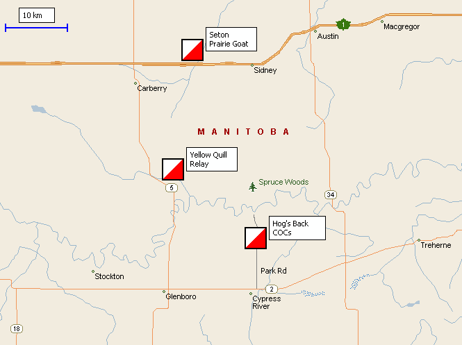
Directions to Parking and Assembly Area
From west (Brandon):
From the junction of the Trans-Canada and 1st Street North in Brandon, travel
41.7 km east on the Trans-Canada to the junction with Highway #5 and then an
additional 8.2 km. You will see an orienteering sign telling you to turn left
(north), cross the westbound lanes of the Trans-Canada and proceed on the
vehicle trail for 250 meters to the parking area.
From south (Carberry):
From the junction of Highway #5 and Provincial Road 351, travel 3.7 km north on
Highway #5, turn right (east) and travel 8.2 km. You will see an orienteering
sign telling you to turn left (north), cross the westbound lanes of the
Trans-Canada and proceed on the vehicle trail for 250 meters to the parking
area.
From east (Winnipeg):
From the junction of the Trans-Canada and Highway #34, travel 22 km west on the
Trans-Canada. You will see a sign indicating a picnic area. From the sign travel
2.6 km until you see an orienteering sign telling you to turn right (north).
Turn onto the vehicle trail and proceed for 250 meters to the parking area.
From north (Neepawa):
From the junction of the Yellowhead Highway #16 and Highway #5, travel south on
Highway #5 for 42.2 km to the junction with the Trans-Canada. Turn left (east)
on the Trans-Canada and travel for 8.2 km. You will see an orienteering sign
telling you to turn left (north), cross the westbound lanes of the Trans-Canada
and proceed on the vehicle trail for 250 meters to the parking area.
Road
Maps:
Overview Map
Detailed Map