
Manitoba Sandhills Orienteering Festival

2009 Manitoba Sandhills Orienteering Festival
Canadian Orienteering Championships
Important Note
The information on this web page is superseded by the Competitor Handbook.
Please refer to the handbook for the most up-to-date information.
Course Data
The COF Course and Category Guidelines (Amended 2009 – M45-54 on Sprint Course 5 and W21-34E on Sprint Course 4) will be used. See the following table for map scales.
| Event | Map Scale |
| COC Sprint | 1 : 5,000 |
| COC Middle | 1 : 10,000 |
| COC Long | 1 : 10,000 for courses 1-8 1 : 15,000 for courses 9-10 |
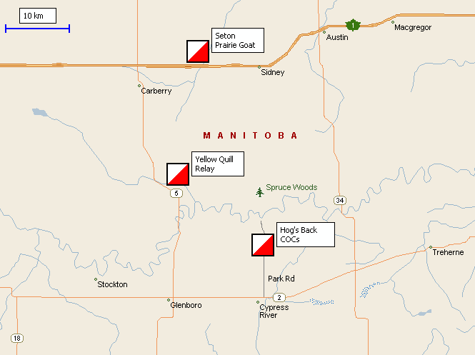
Hog's Back Map
![]()
The Hog's Back map was produced in the spring and summer of 2008. The map was drawn to ISOM by the mapping company Olles with the fieldwork being done by Ales Hejna and Vendula Hejnova. Unlike many previous maps made in Manitoba, the middle and long distance maps have 5m contours as opposed to 2.5m. The sprint map is drawn to ISSOM with 2.5m contours at a scale of 1:5,000. The middle and long courses will be run on a scale of 1:10,000, except for courses 9 and 10 of the long event (WRE), which will be at 1:15,000. Due to the recent fieldwork and drawing, the map is very accurate. Each event is primarily set in a different section of the map. These championship events will mark the first time this map has been used for orienteering.
Terrain
Spruce Woods Park is “characterized by spruce parkland, upland deciduous forest, mixed-grass prairie, open and stabilized sand dunes and riverbottom forest.” The Hog's Back map is set in true wilderness. The area has a mixture of long, detailed sandhill ridges that are covered with short prairie grass, and pockets of deciduous forest in low lying areas. Distinct coniferous trees are dispersed throughout the map. The contours are quite detailed with numerous small & elongated knolls, form lines, small depressions, re-entrants, and spurs. Many of the hills look similar to each other and are in close proximity. The runnability in the open areas is very good, but there are large areas of low-lying primary and secondary green which will be slow-going, especially in late August. There is a minimal amount of open (white) forest and a minimal number of man-made features (trails, buildings, and power lines). There are no rock features. Ales’ comments on the terrain are “Several prominent sand dune ridges with shallower knolls, depressions in between. In open areas, fast with well recognizable features. In forest, slow with very low visibility - very hard to keep in touch with map.”
There are no available maps of the specific terrain because the Hog's Back map has never been used for orienteering before. For some maps with similar terrain, please see the COF Route Gadget database for Manitoba events, specifically the ones from 9th and 10th October 2005. This type of terrain will be used on all 3 COC events.
Awards
For each competitive class, medals will be awarded to the top three eligible Canadian competitors. Prizes will also be given to the top three overall competitors.
To be eligible for the COC awards you must either be a Canadian Citizen or a Permanent Resident as defined by the Dept. Citizenship & Immigration.
World Ranking Events
Because the COC Sprint and COC Long are World Ranking Events, the IOF Rules apply to the elite classes at these events.
Please note that a recent change to the IOF Rules will forbid carrying (as opposed to using) navigational aids other than a map and compass. This applies to GPS watches and other devices that can provide "position, direction, distance, or altitude" information during a race. GPS data loggers that cannot provide such information during a race are still allowed. See the IOF's clarification and this news article for more information.
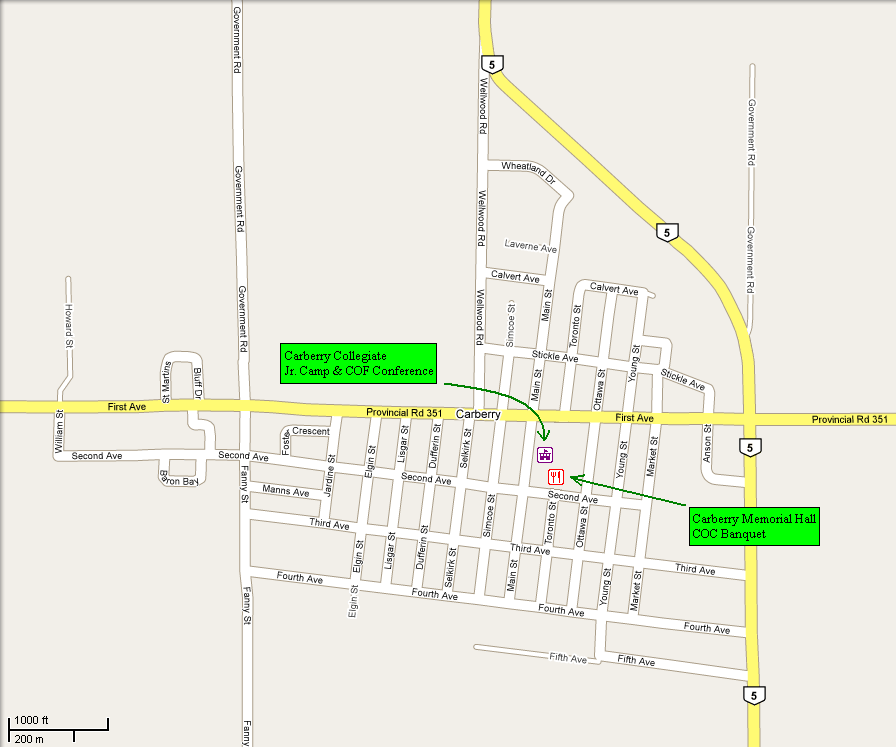
Banquet
The COC banquet will be held at the Carberry Memorial Hall on Saturday 29th August at 6:00PM.
A traditional Manitoba country meal will be served with all the trimmings.
The menu includes a choice of Roast Beef OR Sweet and Sour Chicken
Breast OR Vegetarian Lasagna. There will also be a buffet
with:
· Mashed Potatoes and Gravy
· Rice Pilaf
· Honey Dill Carrots
· Caesar Salad
· Pasta Salad
· Marinated Vegetable Salad
· Veggie and Dip Tray
· Pickle Tray
· Homemade Buns and Butter
· Coffee and Tea
· Lemonade
· Skor Bar Cake
· Cherry and Blueberry
Cheesecake
A cash bar will be available.
Silent Auction
During the COC banquet, a silent auction will be held to raise money for the Junior and Senior National Teams.
If you want to donate something, please e-mail Ursula Goeres as soon as possible.
Officials
| Meet Director | Dave Graupner |
| Course Planners | Tim Lee (Sprint & Middle) Muriel Gamey (Long) |
| Controllers | Sheldon Friesen (Sprint & Middle) Lois Watts (Long) |
| WRE Advisor | Adrian Zissos (Sprint & Long) |
Directions to Parking
COC Model, Sprint, Middle, and Long
Directions to Hog’s Back (Model Event Fri. Aug. 28, 9 a.m. - 6 p.m.; Sprint Fri. Aug. 28 at 2 p.m.; Middle Distance Sat. Aug. 29 at 10 a.m.; Long Distance, Sun. Aug. 30 at 10 a.m.)
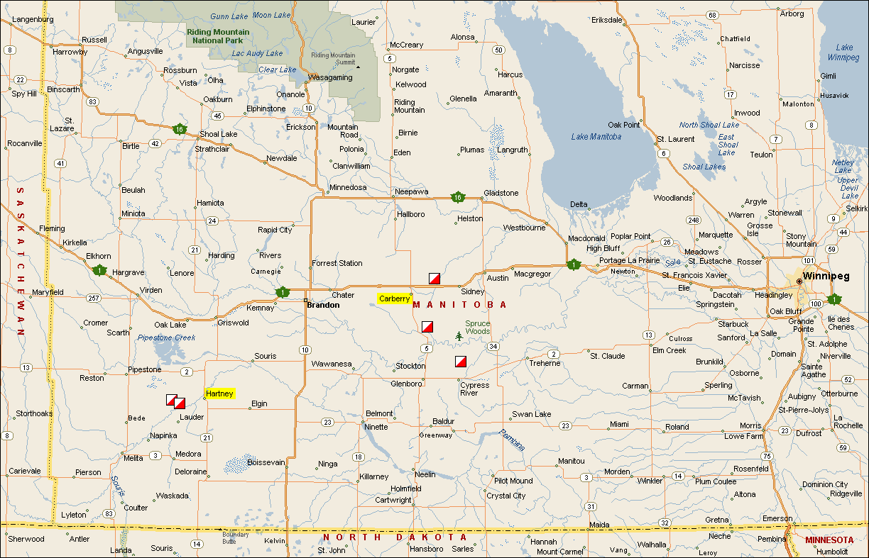
From Winnipeg:
Take Highway 1 (Trans Canada) west to Elie about 46 km.
Turn south from Highway 1 onto Provincial Road 248 at Elie.
Drive 18.5 km to Highway 2
Bear right on Highway 2 and travel along it for 98.8 km
Turn right at Park Road which is before Cypress River
Follow Park Road approximately 6.6 km and watch for orienteering signs.
From Carberry:
Go south on Highway 5 for 37.2 km to Highway # 2.
Turn left on Highway 2 for 14.8 km to Park Road
Turn left at Park Road after Cypress River
Follow Park Road approximately 6.6 km and watch for orienteering signs.
From Brandon:
Go south on Highway 10 for about 30 km to Highway #2
Turn left on Highway 2 for 65.6 km to Park Road
Turn left at Park Road after Cypress River
Follow Park Road approximately 6.6 km and watch for orienteering signs.
COC Banquet
Directions to Banquet in Carberry, Manitoba Sat. Aug. 29 at 6 p.m.
From Winnipeg:
Take Highway 1 (Trans Canada) to Highway 5, approximately 2 hours
Turn left at Highway 5 into Carberry (about 3.7 km)
Turn right on First Ave. (about 0.6 km)
Turn left on Toronto St. (about 0.2 km)
From Brandon:
Take Highway 1 (Trans Canada) to Highway 5, approximately 40 minutes
Turn right at Highway 5 into Carberry (about 3.7 km)
Turn right on First Ave. (about 0.6 km)
Turn left on Toronto St. (about 0.2 km)
Road Maps